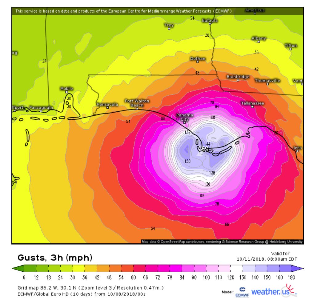
The National Hurricane Center’s latest advisory on Hurricane Michael shows the storm has strengthened into a major hurricane with maximum sustained winds of 120 mph.
The NHC 4 p.m. CDT update states:
MICHAEL STRENGTHENS TO A MAJOR HURRICANE……LIFE-THREATENING STORM SURGE…HURRICANE FORCE WINDS…AND HEAVY RAINFALL EXPECTED ALONG THE NORTHEASTERN GULF COAST…
SUMMARY OF 4 p.m. PM CDT —
- LOCATION 26.0N 86.4W
- ABOUT 295 MI S OF PANAMA CITY FLORIDA
- MAXIMUM SUSTAINED WINDS 120 MPH
- PRESENT MOVEMENT N AT 12 MPH
- MINIMUM CENTRAL PRESSURE 957 MB
WATCHES AND WARNINGS
CHANGES WITH THIS ADVISORY:
A Tropical Storm Warning has been issued from Fernandina Beach Florida to South Santee River South Carolina.
A Tropical Storm Watch has been issued from South Santee River South Carolina to Duck North Carolina, including Pamlico and Albemarle Sounds.
SUMMARY OF WATCHES AND WARNINGS IN EFFECT:
A Storm Surge Warning is in effect for Okaloosa/Walton County Line Florida to Anclote River Florida
A Storm Surge Watch is in effect for Anclote River Florida to Anna Maria Island Florida, including Tampa Bay and Alabama/Florida border to Okaloosa/Walton County Line Florida
A Hurricane Warning is in effect for Alabama/Florida border to Suwannee River Florida
A Tropical Storm Warning is in effect for Alabama/Florida border to the Mississippi/Alabama border, Suwanee River Florida to Chassahowitzka Florida and Fernandina Beach Florida to South Santee River South Carolina
A Tropical Storm Watch is in effect for Chassahowitzka to Anna Maria Island Florida, including Tampa Bay, Mississippi/Alabama border to the Mouth of the Pearl River, South Santee River South Carolina to Duck North Carolina and Pamlico and Albemarle Sounds
DISCUSSION AND OUTLOOK — the eye of Hurricane Michael was located near latitude 26.0 North, longitude 86.4 West. Michael is moving toward the north near 12 mph. A northward motion is expected through tonight, followed by a northeastward motion on Wednesday and Thursday. On the forecast track, the center of Michael will move across the eastern Gulf of Mexico through tonight. The center of Michael is then expected to move inland over the Florida Panhandle or Florida Big Bend area on Wednesday, and then move northeastward across the southeastern United States Wednesday night and Thursday, and move off the Mid-Atlantic coast away from the United States on Friday. Maximum sustained winds have increased to near 120 mph with higher gusts. Michael is a category 3 hurricane on the Saffir-Simpson Hurricane Wind Scale. Some additional strengthening is expected, and Michael is forecast to be a major hurricane at landfall in Florida. Weakening is expected after landfall as Michael moves through the southeastern United States. Hurricane-force winds extend outward up to 45 miles from the center and tropical-storm-force winds extend outward up to 175 miles.
The latest minimum central pressure based on data from an Air Force Reserve Hurricane Hunter aircraft is 957 mb.
HAZARDS AFFECTING LAND —
STORM SURGE: The combination of a dangerous storm surge and the tide will cause normally dry areas near the coast to be flooded by rising waters moving inland from the shoreline. The water has the potential to reach the following heights above ground if peak surge occurs at the time of high tide…
- Mexico Beach FL to Keaton Beach FL…9-13 ft
- Okaloosa/Walton County Line FL to Mexico Beach FL…6-9 ft
- Keaton Beach FL to Cedar Key FL…6-9 ft
- Cedar Key FL to Chassahowitzka FL…4-6 ft
- Chassahowitzka to Anna Maria Island FL including Tampa Bay…2-4 ft
- Alabama/Florida border to Okaloosa/Walton County Line FL…2-4 ft
WIND: Hurricane conditions are expected within the hurricane warning area along the U.S. Gulf Coast by Wednesday, with tropical storm conditions expected by tonight or early Wednesday. Hurricane conditions will also spread well inland across portions of the Florida Panhandle, southeastern Alabama and southwestern Georgia.
Tropical storm conditions are expected in the tropical storm warning area by tonight or early Wednesday, and are possible within the tropical storm watch area by that time. Hurricane conditions are possible within the hurricane watch area by Wednesday.
Tropical storm conditions are expected in the warning area along the southeast U.S. coast by Wednesday, and possible in the watch area by late Wednesday.
RAINFALL: Michael is expected to produce the following rainfall amounts through Friday…
Florida Panhandle and Big Bend, southeast Alabama, and portions of southwest and central Georgia…4 to 8 inches, with isolated maximum amounts of 12 inches. This rainfall could lead to life threatening flash floods.
The remainder of Georgia, the Carolinas, and southern Virginia…3 to 6 inches, with isolated maximum amounts of 8 inches. This rainfall could lead to life-threatening flash floods.
Florida Peninsula, eastern Mid Atlantic, southern New England coast…1-3 inches.
SURF: Swells generated by Michael are affecting the coasts of the eastern and northern Gulf of Mexico, and will spread to portions of the northwestern and western Gulf of Mexico coast during the next day or so. These swells are likely to cause life-threatening surf and rip current conditions. Please consult products from your local weather office.
TORNADOES: The threat for tornadoes will increase late tonight into Wednesday over parts of the Florida Panhandle, the northern Florida Peninsula, and southern Georgia.
NEXT ADVISORY ————- Next intermediate advisory at 700 PM CDT. Next complete advisory at 1000 PM CDT.


