


…SALLY A LITTLE STRONGER, ADDITIONAL STRENGTHENING EXPECTED
TONIGHT…
…LIFE-THREATENING STORM SURGE, HURRICANE-FORCE WINDS, AND FLASH
FLOODING LIKELY ALONG PORTIONS OF THE NORTHERN GULF COAST STARTING
TONIGHT AND TUESDAY…
SUMMARY OF 400 PM CDT…2100 UTC…INFORMATION
———————————————-
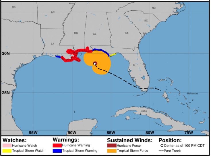
LOCATION…28.8N 87.4W
ABOUT 105 MI…170 KM E OF THE MOUTH OF THE MISSISSIPPI RIVER
ABOUT 145 MI…230 KM SE OF BILOXI MISSISSIPPI
MAXIMUM SUSTAINED WINDS…100 MPH…155 KM/H
PRESENT MOVEMENT…WNW OR 300 DEGREES AT 6 MPH…9 KM/H
MINIMUM CENTRAL PRESSURE…987 MB…29.15 INCHES
WATCHES AND WARNINGS
——————–
CHANGES WITH THIS ADVISORY:
The Storm Surge Warning has been extended eastward along the coast
of the Florida panhandle to the Okaloosa/Walton County Line.
The Hurricane Warning has been extended eastward along the coast
of the Florida Panhandle to Navarre.
The Tropical Storm Warning west of Morgan City Louisiana has been
discontinued.
The Tropical Storm Watch along the coast of the Florida Panhandle
has been discontinued.
SUMMARY OF WATCHES AND WARNINGS IN EFFECT:
A Storm Surge Warning is in effect for…
* Port Fourchon Louisiana to the Okaloosa/Walton County Line Florida
* Lake Pontchartrain, Lake Maurepas, and Lake Borgne
* Mobile Bay
A Hurricane Warning is in effect for…
* Morgan City Louisiana to the Navarre Florida
* Lake Pontchartrain and Lake Maurepas including metropolitan New
Orleans
A Tropical Storm Warning is in effect for…
* East of of Navarre Florida to Indian Pass Florida
A Storm Surge Warning means there is a danger of life-threatening
inundation, from rising water moving inland from the coastline,
during the next 36 hours in the indicated locations. For a depiction
of areas at risk, please see the National Weather Service Storm
Surge Watch/Warning Graphic, available at hurricanes.gov. This is a
life-threatening situation. Persons located within these areas
should take all necessary actions to protect life and property from
rising water and the potential for other dangerous conditions.
Promptly follow evacuation and other instructions from local
officials.
A Hurricane Warning means that hurricane conditions are expected
somewhere within the warning area. Preparations to protect life
and property should be rushed to completion.
A Tropical Storm Warning means that tropical storm conditions are
expected somewhere within the warning area within 36 hours.
For storm information specific to your area, including possible
inland watches and warnings, please monitor products issued by your
local National Weather Service forecast office.
DISCUSSION AND OUTLOOK
———————-
At 400 PM CDT (2100 UTC), the center of Hurricane Sally was located
near latitude 28.8 North, longitude 87.4 West. Sally is moving
toward the west-northwest near 6 mph (9 km/h), and this motion is
expected to continue through tonight. A northward turn is expected
by Tuesday, and a slow north-northeastward to northeastward motion
is expected Tuesday night through Wednesday night. On the forecast
track, the center of Sally will move near the coast of southeastern
Louisiana tonight and Tuesday, and make landfall in the hurricane
warning area on late Tuesday or Wednesday.
Data from reconnaissance aircraft indicate that the maximum
sustained winds have increased to near 100 mph (155 km/h) with
higher gusts. Additional strengthening is forecast tonight and
early Tuesday and Sally is expected to be a dangerous hurricane when
it moves onshore along the north-central Gulf coast.
Hurricane-force winds extend outward up to 25 miles (35 km) from the
center and tropical-storm-force winds extend outward up to 125 miles
(205 km).
The latest minimum central pressure estimated from data from an Air
Force Reserve reconnaissance aircraft is 987 mb (29.15 inches).
HAZARDS AFFECTING LAND
———————-
Key messages for Sally can be found in the Tropical Cyclone
Discussion under AWIPS header MIATCDAT4 and WMO header WTNT44 KNHC,
and on the web at www.hurricanes.gov/text/MIATCDAT4.shtml
STORM SURGE: The combination of a dangerous storm surge and the
tide will cause normally dry areas near the coast to be flooded by
rising waters moving inland from the shoreline. The water could
reach the following heights above ground somewhere in the indicated
areas if the peak surge occurs at the time of high tide…
Mouth of the Mississippi River to Ocean Springs, MS including Lake
Borgne…7-11 ft
Ocean Springs, MS to Dauphin Island, AL including Mobile Bay…6-9
ft
Dauphin Island, AL to AL/FL Border…4-7 ft
Lake Pontchartrain and Lake Maurepas…3-5 ft
Port Fourchon, LA to Mouth of the Mississippi River…2-4 ft
AL/FL Border to Okaloosa/Walton County Line, FL including Pensacola
Bay and Choctawhatchee Bay…2-4 ft
Okaloosa/Walton County Line, FL to Chassahowitzka, FL including
Saint Andrew Bay…1-3 ft
Burns Point, LA to Port Fourchon, LA…1-2 ft
Overtopping of local levees outside of the Hurricane and Storm
Damage Risk Reduction System is possible where local inundation
values may be higher than those shown above.
The deepest water will occur along the immediate coast in areas of
onshore winds, where the surge will be accompanied by large and
damaging waves. Surge-related flooding depends on the relative
timing of the surge and the tidal cycle, and can vary greatly over
short distances. For information specific to your area, please see
products issued by your local National Weather Service forecast
office.
WIND: Hurricane conditions are expected to begin within the
hurricane warning area late tonight and Tuesday. Tropical storm
conditions expected to begin within the warning area this evening.
RAINFALL: Sally is expected to be a slow moving system as it
approaches land, producing 8 to 16 inches of rainfall with isolated
amounts of 24 inches over portions of the central Gulf Coast from
the western Florida Panhandle to far southeast Louisiana through the
middle of the week. Life-threatening flash flooding is likely. In
addition, this rainfall will likely lead to widespread minor to
isolated major flooding on area rivers.
Sally is forecast to move farther inland early Wednesday and track
across the Southeast producing rainfall of 4 to 8 inches, with
isolated maximum amounts of 12 inches, across portions of eastern
Mississippi, central Alabama, northern Georgia and the western
Carolinas. Significant flash and urban flooding is likely, as well
as widespread minor to moderate flooding on some rivers.
Outer bands of Sally are expected to produce additional rainfall of
1 to 3 inches across the Florida peninsula today. This rainfall may
produce flash and urban flooding and prolong high flows and ongoing
minor flooding on rivers across central Florida.
TORNADOES: A tornado or two are possible through tonight over
coastal areas of the Florida Panhandle and southern Alabama. The
threat of tornadoes is expected to increase on Tuesday in these
areas, as well as over parts of southern Mississippi and extreme
southeast Louisiana.
SURF: Swells from Sally will continue to affect areas from the
west coast of the Florida peninsula westward through the coast of
southeastern Louisiana during the next couple of days. These swells
are likely to cause life-threatening surf and rip current
conditions. Please consult products from your local weather office.


