


NAVARRE AREA BOARD OF REALTORS
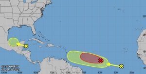
Tropical Weather Outlook NWS National Hurricane Center Miami FL 200 PM EDT Fri Jun 28 2024 For the North Atlantic…Caribbean Sea and the Gulf of Mexico:
1. Western Caribbean/Southwestern Gulf of Mexico (AL94): An area of low pressure over the western Caribbean Sea associated with a tropical wave continues to produce widespread shower and thunderstorm activity. Development of this disturbance is not expected today while it moves west-northwestward at 10 to 15 mph. The disturbance is forecast move westward over the Yucatan Peninsula and emerge over the Bay of Campeche late Saturday or early Sunday, at which point some development will be possible. Regardless of development, heavy rainfall associated with the tropical wave will affect portions of Central America and Mexico through the weekend. * Formation chance through 48 hours…low…30 percent. * Formation chance through 7 days…low…30 percent.
2. Central Tropical Atlantic (AL95): A low pressure system located about 1400 miles east-southeast of the Windward Islands is becoming better defined and the associated showers and thunderstorms are increasing in organization. If these trends continue, a tropical depression will likely form later today. This system is expected to move westward at 15 to 20 mph and approach the Windward Islands by the end of the weekend, and Hurricane or Tropical Storm Watches could be required for portions of that region tonight or early Saturday. For more information, including gale warnings, see High Seas Forecasts issued by the National Weather Service. * Formation chance through 48 hours…high…near 100 percent. * Formation chance through 7 days…high…near 100 percent.
3. Eastern Tropical Atlantic: A tropical wave located several hundred miles south-southwest of the Cabo Verde Islands is producing disorganized showers and thunderstorms. Some slow development of this system is possible next week while it moves generally westward at 15 to 20 mph across the central and western tropical Atlantic. * Formation chance through 48 hours…low…near 0 percent. * Formation chance through 7 days…low…30 percent.