


NATIONAL HURRICANE CENTER 10 A.M. UPDATE:
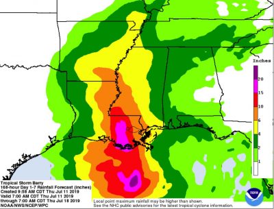
...DISTURBANCE BECOMES TROPICAL STORM BARRY...
...DANGEROUS STORM SURGE, HEAVY RAINS, AND WIND CONDITIONS EXPECTED
ACROSS THE NORTH-CENTRAL GULF COAST...


SUMMARY OF 1000 AM CDT...1500 UTC...INFORMATION
-----------------------------------------------
LOCATION...27.8N 88.7W
ABOUT 95 MI...150 KM SSE OF THE MOUTH OF THE MISSISSIPPI RIVER
ABOUT 200 MI...320 KM SE OF MORGAN CITY LOUISIANA
MAXIMUM SUSTAINED WINDS...40 MPH...65 KM/H
PRESENT MOVEMENT...W OR 270 DEGREES AT 5 MPH...7 KM/H
MINIMUM CENTRAL PRESSURE...1005 MB...29.68 INCHES


WATCHES AND WARNINGS
--------------------
CHANGES WITH THIS ADVISORY...

A Tropical Storm Warning is now in effect for the Louisiana coast
from the Mouth of the Pearl River to Morgan City.

A Storm Surge Warning is now in effect for the Louisiana coast from
the Mouth of the Atchafalaya River to Shell Beach.

A Tropical Storm Watch is now in effect for the Mississippi coast
east of the Mouth of the Pearl River to the Mississippi/Alabama
border...and for Lake Pontchartrain and Lake Maurepas including
metropolitan New Orleans.

A Storm Surge Watch is now in effect for the Mississippi coast from
the Mouth of the Pearl River to the Mississippi/Alabama border.

SUMMARY OF WATCHES AND WARNINGS IN EFFECT...

A Tropical Storm Warning is in effect for...
* Mouth of the Pearl River to Morgan City

A Storm Surge Warning is in effect for...
* Mouth of the Atchafalaya River to Shell Beach

A Storm Surge Watch is in effect for...
* Shell Beach to the Mississippi/Alabama border
* Mouth of the Atchafalaya River to Intracoastal City

A Hurricane Watch is in effect for...
* Mouth of the Mississippi River to Cameron

A Tropical Storm Watch is in effect for...
* East of the Mouth of the Pearl River to the Mississippi/Alabama
border
* Lake Pontchartrain and Lake Maurepas including metropolitan New
Orleans

A Tropical Storm Warning means that tropical storm conditions are
expected somewhere within the warning area within 36 hours.

A Storm Surge Warning means there is a danger of life-threatening
inundation from rising water moving inland from the coastline
during the next 36 hours in the indicated locations.  For a
depiction of areas at risk please see the National Weather
Service Storm Surge Watch/Warning Graphic available at
hurricanes.gov.  This is a life-threatening situation.  Persons
located within these areas should take all necessary actions to
protect life and property from rising water and the potential for
other dangerous conditions.  Promptly follow evacuation and other
instructions from local officials.

A Storm Surge Watch means there is a possibility of life-
threatening inundation from rising water moving inland from the
coastline in the indicated locations during the next 48 hours.

A Hurricane Watch means that hurricane conditions are possible
within the watch area.  A watch is typically issued 48 hours
before the anticipated first occurrence of tropical-storm-force
winds conditions that make outside preparations difficult or
dangerous.

A Tropical Storm Watch means that tropical storm conditions are
possible within the watch area generally within 48 hours.

Additional watches and warnings may be required for portions of the
northern Gulf coast later today or tonight. Interests elsewhere
along the Gulf Coast from the Upper Texas Coast to the Florida
Panhandle should monitor the progress of this system.

For storm information specific to your area, including possible
inland watches and warnings, please monitor products issued by your
local National Weather Service forecast office.


DISCUSSION AND OUTLOOK
----------------------
At 1000 AM CDT (1500 UTC), the center of Tropical Storm Barry was
located near latitude 27.8 North, longitude 88.7 West. Barry is
moving toward the west near 5 mph (7 km/h) and this motion is
expected to continue today.  A turn toward the west-northwest is
expected tonight, followed by a turn toward the northwest on
Friday.  On the forecast track the center of Barry will be near the
central or southeastern coast of Louisiana Friday night or Saturday.

Reports from Air Force Reserve and NOAA Hurricane Hunter aircraft
indicate that maximum sustained winds have increased to near 40 mph
(65 km/h) with higher gusts.  Additional strengthening is expected
during the next day or two, and Barry could become a hurricane late
Friday or early Saturday.

Tropical-storm-force winds extend outward up to 90 miles (150 km)
mainly to the southeast of the center.

The estimated minimum central pressure is 1005 mb (29.68 inches).


HAZARDS AFFECTING LAND
----------------------
Key Messages for Barry can be found in the Tropical Cyclone
Discussion under AWIPS header MIATCDAT2 and WMO header WTNT32 KNHC.

STORM SURGE:  The combination of a dangerous storm surge and the
tide will cause normally dry areas near the coast to be flooded by
rising waters moving inland from the shoreline.  The water could
reach the following heights above ground somewhere in the indicated
areas if the peak surge occurs at the time of high tide...

Mouth of the Atchafalaya River to Shell Beach...3 to 6 ft
Shell Beach to the Mississippi/Alabama border...2 to 4 ft
Intracoastal City to the Mouth of the Atchafalaya River...2 to 4 ft
Lake Pontchartrain...1 to 3 ft

Surge-related flooding depends on the relative timing of the surge
and the tidal cycle, and can vary greatly over short distances. For
information specific to your area, please see products issued by
your local National Weather Service forecast office.

RAINFALL:  Barry is expected to produce total rain accumulations of
10 to 15 inches near and inland of the central Gulf Coast through
early next week, with isolated maximum rainfall amounts of 20 inches
across portions of eastern Louisiana and southern Mississippi.

WIND:  Tropical storm conditions are expected in the Tropical
Storm Warning area by Friday.  Hurricane conditions are possible
within the Hurricane Watch area by Friday night, with tropical storm
conditions possible in the Tropical Storm Watch area by Friday
night or Saturday.

TORNADOES:  A tornado or two are possible tonight and Friday across
southern portions of Louisiana and Mississippi.


NEXT ADVISORY
-------------
Next intermediate advisory at 100 PM CDT.
Next complete advisory at 400 PM CDT.


