


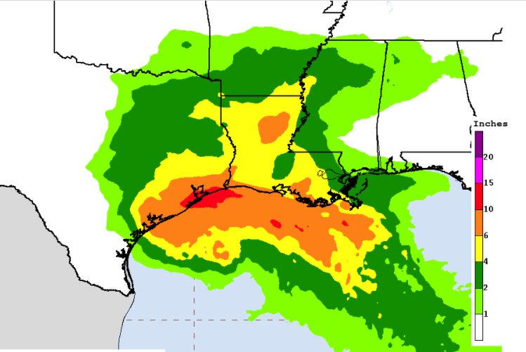
The National Hurricane Center's 7 a.m. update shows that Tropical Storm Beta is moving slowly west-northwest toward the Texas Coast.

SUMMARY OF 700 AM CDT...1200 UTC...INFORMATION
----------------------------------------------
LOCATION...27.1N 92.8W
ABOUT 200 MI...320 KM SE OF GALVESTON TEXAS
ABOUT 290 MI...460 KM E OF CORPUS CHRISTI TEXAS
MAXIMUM SUSTAINED WINDS...60 MPH...95 KM/H
PRESENT MOVEMENT...WNW OR 290 DEGREES AT 3 MPH...6 KM/H
MINIMUM CENTRAL PRESSURE...997 MB...29.44 INCHES

WATCHES AND WARNINGS
--------------------
CHANGES WITH THIS ADVISORY:

None.

SUMMARY OF WATCHES AND WARNINGS IN EFFECT:

A Storm Surge Warning is in effect for...
* Port Aransas, Texas to Rockefeller Wildlife Refuge, Louisiana, including Copano Bay, Aransas Bay, San Antonio Bay, Matagorda Bay,
Galveston Bay, Sabine Lake, and Lake Calcasieu

A Tropical Storm Warning is in effect for...
* Port Aransas Texas to Morgan City Louisiana

A Tropical Storm Watch is in effect for...
* Port Mansfield to Port Aransas Texas

A Storm Surge Warning means there is a danger of life-threatening inundation, from rising water moving inland from the coastline,
during the next 36 hours in the indicated locations. For a depiction of areas at risk, please see the National Weather Service Storm
Surge Watch/Warning Graphic, available at hurricanes.gov.  This is a life-threatening situation.  Persons located within these areas
should take all necessary actions to protect life and property from rising water and the potential for other dangerous conditions.
Promptly follow evacuation and other instructions from local officials.

DISCUSSION AND OUTLOOK
----------------------
At 700 AM CDT (1200 UTC), the center of Tropical Storm Beta was located near latitude 27.1 North, longitude 92.8 West. Beta is
moving toward the west-northwest near 3 mph (6 km/h). A slightly faster motion toward the west-northwest is forecast to occur during
the next couple of days, followed by a slow down and a turn to the north and northeast Monday night and Tuesday. On the forecast track,
the center of Beta will move toward the coast of Texas and will likely move inland Monday or Monday night.

Maximum sustained winds are near 60 mph (95 km/h) with higher gusts. Little change in strength is forecast during the next couple
of days before Beta reaches the Texas coast. Weakening is anticipated once Beta moves inland.

Tropical-storm-force winds extend outward up to 195 miles (315 km) from the center.

The estimated minimum central pressure is 997 mb (29.44 inches) based on reports from nearby oil platforms.


HAZARDS AFFECTING LAND
----------------------
Key messages for Beta can be found in the Tropical Cyclone
Discussion under AWIPS header MIATCDAT2 and WMO header WTNT42 KNHC.

STORM SURGE:  The combination of a dangerous storm surge and the tide will cause normally dry areas near the coast to be flooded by
rising waters moving inland from the shoreline.  The water could reach the following heights above ground somewhere in the indicated
areas if the peak surge occurs at the time of high tide...

Rockefeller Wildlife Refuge, LA to Ocean Springs, MS including Vermilion Bay, Lake Borgne, Lake Pontchartrain, and Lake Maurepas...1-3 ft ft

Port Aransas, TX to Rockefeller Wildlife Refuge, LA including Copano Bay, Aransas Bay, San Antonio Bay, Matagorda Bay, Galveston
Bay, Sabine Lake, and Calcasieu Lake... 2-4 ft

Baffin Bay, TX to Port Aransas, TX including Corpus Christi Bay and Baffin Bay... 1-3 ft

Mouth of the Rio Grande to Baffin Bay, TX...1-2 ft

The deepest water will occur along the immediate coast in areas of onshore winds, where the surge will be accompanied by large and
dangerous waves.  Surge-related flooding depends on the relative timing of the surge and the tidal cycle, and can vary greatly over
short distances.  For information specific to your area, please see products issued by your local National Weather Service forecast
office.

WIND:  Tropical storm conditions are occurring in the tropical storm warning area along the southwestern Louisiana coast and will
spread westward to the warning areas in Texas late today through early Monday. Tropical storm conditions are possible within the
tropical storm watch area along the south Texas coast on Monday.
RAINFALL:  Through Thursday, Beta is expected to produce rainfall accumulations of 8 to 12 inches with isolated totals of 20 inches
from the middle Texas coast to southern Louisiana, with 4 to 8 inches spreading northward into the lower Mississippi River Valley
by mid-week. Flash and urban flooding is likely, as well as minor to isolated moderate river flooding.

TORNADOES:  A tornado or two could occur Monday near the middle-to-upper Texas coast or the southwestern Louisiana coast.

SURF:  Swells are increasing and reaching the coast of Texas and the Gulf Coast of Mexico, generated by a combination of Beta and a
cold front entering the northern Gulf of Mexico.  These swells are likely to cause life-threatening surf and rip current conditions.
Please consult products from your local weather office.


