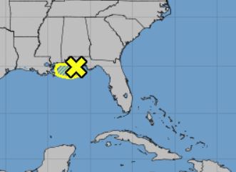
The National Hurricane Center's 1 p.m. CDT Tropical Weather Outlook indicated a low-pressure area in the north-central Gulf of Mexico.
According to the update, a large area of disorganized showers and thunderstorms extending from the north-central Gulf of Mexico across the western Florida panhandle is associated with a broad area of low pressure and
associated surface trough. Close proximity to land should prevent significant development of this system before it moves westward and
inland over southeastern Louisiana on Tuesday.

Regardless of development, NHC says system is forecast to produce locally heavy rainfall along portions of the northern Gulf Coast during the next
couple of days.
* Formation chance through 48 hours...low...10 percent.
* Formation chance through 5 days...low...10 percent.


