


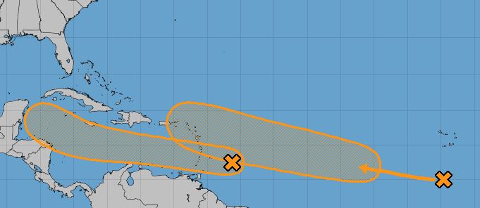
The National Hurricane Center’s 8 a.m. EDT update shows two tropical systems are currently being monitored in the Atlantic.
Per NHC ,the first system is a fast-moving tropical wave located a couple of hundred miles east of the Windward Islands continues to produce disorganized shower and thunderstorm activity. This disturbance is expected to move westward at about 20 mph during the next few days, and that fast forward speed is likely to limit significant development while the system approaches the Windward and southern Leeward Islands today, and moves across the eastern and central Caribbean Sea on Tuesday and Wednesday. After that time, however, the system is expected to move more slowly westward across the western Caribbean Sea, where upper-level winds could become more conducive for the development of a tropical depression during the latter part of this week. Regardless of development, locally heavy rainfall and gusty winds are expected over portions of the Windward and southern Leeward Islands beginning today through Tuesday morning.
* Formation chance through 48 hours…low…20 percent.
* Formation chance through 5 days…medium…50 percent.
The second system is a tropical wave located over the eastern tropical Atlantic to the south-southwest of the Cabo Verde Islands is producing disorganized cloudiness and showers. The wave is forecast to move westward to west-northwestward at 15 to 20 mph during the next few days, and environmental conditions are expected to become more conducive for the development of a tropical depression during the middle-to-latter part of this week while the system moves across the central and western portions of the tropical Atlantic.
* Formation chance through 48 hours…low…20 percent.
* Formation chance through 5 days…medium…60 percent.


