


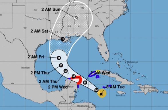
The hurricane is in the midst of a very impressive rapid intensification episode, having strengthened over 50 kt during the past 24 hours, per the National Hurricane Center (NHC).
Model guidance has again shifted westward, like the last cycle, and the official forecast is trended in that direction. However, it remains slightly east of the model consensus, due to a notable westward bias in some of the guidance during this hurricane season. Users are reminded to not focus on the details of the track or intensity forecasts, as the average 4-day track error is around 150 miles and the average 4-day intensity error is close to 15 mph, stated NHC.
National Hurricane Center’s 8 a.m. EDT update:
800 AM EDT Tue Oct 06 2020

...NOAA HURRICANE HUNTER AIRCRAFT REPORTS THAT DELTA
CONTINUES TO RAPIDLY STRENGTHEN...
...EXTREMELY DANGEROUS HURRICANE CONDITIONS EXPECTED FOR THE
NORTHEASTERN YUCATAN PENINSULA STARTING EARLY WEDNESDAY...

SUMMARY OF 800 AM EDT...1200 UTC...INFORMATION
----------------------------------------------
LOCATION...17.8N 82.0W
ABOUT 370 MI...595 KM ESE OF COZUMEL MEXICO
ABOUT 115 MI...185 KM SSW OF GRAND CAYMAN
MAXIMUM SUSTAINED WINDS...110 MPH...175 KM/H
PRESENT MOVEMENT...WNW OR 300 DEGREES AT 15 MPH...24 KM/H
MINIMUM CENTRAL PRESSURE...962 MB...28.41 INCHES

DISCUSSION AND OUTLOOK
----------------------
At 800 AM EDT (1200 UTC), the center of Hurricane Delta was located
by a NOAA Hurricane Hunter aircraft near latitude 17.8 North,
longitude 82.0 West. Delta is moving toward the west-northwest
near 15 mph (24 km/h).  A faster northwestward motion is expected
to begin later today through Wednesday night.  On the forecast
track, the center of Delta is expected to continue to pass southwest
of the Cayman Islands this morning, and move over the northeastern
portion of the Yucatan peninsula early Wednesday.  Delta is forecast
to move over the southern Gulf of Mexico Wednesday afternoon, and be
over the southern or central Gulf of Mexico through Thursday.

Maximum sustained winds have increased to near 110 mph (175 km/h)
with higher gusts.  Additional strengthening is forecast during the
next 48 hours, and Delta is expected to be a major hurricane when
it moves over the Yucatan Peninsula Wednesday and over the Gulf of
Mexico through Thursday.

Hurricane-force winds extend outward up to 25 miles (35 km) from
the center and tropical-storm-force winds extend outward up to 90
miles (150 km).

The estimated minimum central pressure from NOAA Hurricane Hunter
aircraft data is 962 mb (28.41 inches).


HAZARDS AFFECTING LAND
----------------------
Key messages for Delta can be found in the Tropical Cyclone
Discussion under AWIPS header MIATCDAT1, WMO header WTNT41
KNHC, and on the web at www.hurricanes.gov/text/MIATCDAT1.shtml.

STORM SURGE:  An extremely dangerous storm surge will raise water
levels by as much as 6 to 9 feet above normal tide levels along
coast of the Yucatan peninsula within the hurricane warning area,
near and to right of where the center makes landfall. Near the
coast, the surge will be accompanied by large and dangerous waves.

WIND:  Tropical storm conditions are expected in the Cayman Islands
today.  In the Yucatan Peninsula, hurricane conditions are expected
in the warning area early Wednesday, with tropical storm conditions
beginning later today or tonight.  Tropical storm conditions are
expected in the tropical storm warning area tonight and Wednesday.
In Cuba, tropical storm conditions are expected tonight in the
warning area and possible in the watch area near the same
time.

RAINFALL:  Delta is expected to produce 4 to 6 inches of rain, with
isolated maximum totals of 10 inches, across portions of the
northern Yucatan Peninsula through midweek. This rainfall may result
in areas of significant flash flooding.

Over the next few days, Delta is expected to produce 2 to 4 inches
of rain, with isolated higher amounts, across portions of the Cayman
Islands and western Cuba. This rainfall may result in areas of flash
flooding and mudslides.

Later this week, Delta is expected to bring heavy rainfall to
portions of the central Gulf Coast, Tennessee Valley, and
southeastern United States.

SURF:  Swells generated by Delta will be affected land areas around
the northwestern Caribbean Sea for the next day or so. These swells
are likely to cause life-threatening surf and rip current
conditions.  Please consult products from your local weather office.


NEXT ADVISORY
-------------
Next complete advisory at 1100 AM EDT.

$$
he government of Mexico has extended the Hurricane Warning westward along the north coast of the Yucatan Peninsula to Dzilam. SUMMARY OF WATCHES AND WARNINGS IN EFFECT: A Hurricane Warning is in effect for... * Tulum to Dzilam Mexico * Cozumel A Tropical Storm Warning is in effect for... * Cayman Islands including Little Cayman and Cayman Brac * Cuba province of Pinar del Rio * Isle of Youth * Punta Herrero to Tulum * Dzilam to Progresso A Tropical Storm Watch is in effect for... * Cuba province of La Habana A Hurricane Warning means that hurricane conditions are expected somewhere within the warning area. Preparations to protect life and property should be rushed to completion. A Tropical Storm Warning means that tropical storm conditions are expected somewhere within the warning area within 36 hours. A Tropical Storm Watch means that tropical storm conditions are possible within the watch area, generally within 48 hours. For storm information specific to your area, please monitor products issued by your national meteorological service. DISCUSSION AND OUTLOOK ---------------------- At 500 AM EDT (0900 UTC), the center of Hurricane Delta was located near latitude 17.5 North, longitude 81.3 West. Delta is moving toward the west-northwest near 15 mph (24 km/h). A faster northwestward motion is expected to begin later today through Wednesday night. On the forecast track, the center of Delta is expected to pass southwest of the Cayman Islands this morning, and move over the northeastern portion of the Yucatan peninsula early Wednesday. Delta is forecast to move over the southern Gulf of Mexico Wednesday afternoon, and be over the southern or central Gulf of Mexico through Thursday. Data from an Air Force Reserve Hurricane Hunter aircraft indicate that maximum sustained winds have increased to near 100 mph (155 km/h) with higher gusts. Some strengthening is forecast during the next 48 hours, and Delta is expected to be a major hurricane over the Yucatan Peninsula Wednesday and over the Gulf of Mexico through Thursday. Hurricane-force winds extend outward up to 25 miles (35 km) from the center and tropical-storm-force winds extend outward up to 90 miles (150 km). The latest minimum central pressure reported by an Air Force Reserve Hurricane Hunter aircraft is 968 mb (28.59 inches). HAZARDS AFFECTING LAND ---------------------- Key messages for Delta can be found in the Tropical Cyclone Discussion under AWIPS header MIATCDAT1, WMO header WTNT41 KNHC, and on the web at www.hurricanes.gov/text/MIATCDAT1.shtml. STORM SURGE: An extremely dangerous storm surge will raise water levels by as much as 6 to 9 feet above normal tide levels along coast of the Yucatan peninsula within the hurricane warning area, near and to right of where the center makes landfall. Near the coast, the surge will be accompanied by large and dangerous waves. WIND: Tropical storm conditions are expected in the Cayman Islands later this morning. In the Yucatan Peninsula, hurricane conditions are expected in the warning area early Wednesday, with tropical storm conditions expected later today. Tropical storm conditions are expected in the tropical storm warning area tonight and Wednesday. In Cuba, tropical storm conditions are expected tonight in the warning area and possible in the watch area near the same time. RAINFALL: Delta is expected to produce 4 to 6 inches of rain, with isolated maximum totals of 10 inches, across portions of the northern Yucatan Peninsula through midweek. This rainfall may result in areas of significant flash flooding. Over the next few days, Delta is expected to produce 2 to 4 inches of rain, with isolated higher amounts, across portions of the Cayman Islands and western Cuba. This rainfall may result in areas of flash flooding and mudslides. Later this week, Delta is expected to bring heavy rainfall to portions of the central Gulf Coast, Tennessee Valley, and southeastern United States. SURF: Swells generated by Delta will be affected land areas around the northwestern Caribbean Sea for the next day or so. These swells are likely to cause life-threatening surf and rip current conditions. Please consult products from your local weather office.


